
Theory
As the intrinsic relationship between theory, analysis and design will be addressed in each publication, the ’theory’ part explains the terms and concepts underlying the project.
Temporalities
To better understand the hinterland, perhaps we should not look at it solely as an area, but rather it requires to be seen through the lens of time. Time inhabits all living forms, forcing them to organize themselves and their actions according to temporal logic[1]. According to Darwin, life is linked to the movement of time, transforming being into becoming. His work introduces the concept of the event in which appearances of life evolve and transform themselves.[2] Time does not control the existence but structures it and indicates its actions. It is often manifested in matter and space to capture and structure temporal movement in terms of the transformation of objects. It is also linked to growth, change, and decay.[3]
Similarly for the artist Robert Smithson, referring only to perception and cognition does not provide sufficient methods of analysis. Fascinated by the dichotomy between urban and suburban areas in his work “The Monuments of Passaic,” Smithson, in his narrative, uses different temporalities to reveal the ambiguity and complexity of the space of the suburb: “the psychological time of the individual, the social time of culture and its symbols, and the time of geological change.”[4] It allows to picture and connect different layers of the landscape.[5] “Our perception of it (the suburb), he argues, is the result of learned conventions, such as linear perspective, that present themselves as ‘natural’ conditions but are in fact not. (…) His aim is to precisely disrupt what he sees as the ‘illusion’ of unity in his experience of the suburb.”[6] Smithson’s thinking on time does not only refer to the notion of entropy but also introduces a term of “time-crystals”. A crystal develops by repeating the same arrangements of molecules, more replicating itself rather than progressing and developing[7]. For the notion of time, this idea does not use classic, linear temporality, but rather treats it as “frozen timelessness within temporality itself.”[8]
“Time is deranged. A landslide of diamonds plunges into a polar crevasse of boundless dimension. History no longer exists.”[9]
The illusion and subjectivity of time, create various understandings of the same place. Temporalities see those relations as intertwined fragments of the whole.
Research on the transition of hinterland uses those concepts, in order to delineate different images of the region, accumulating in the city/non-city continuum. Various time frames attempt to show the correlation between certain events and the current phase of Western Macedonia’s existence. If certain characteristics are interwoven, perhaps temporalities will allow us to position ourselves within the next stages of hinterland’s “becoming”.

66 million years
Lignite deposits of West Macedonia are located in over 150 kilometres long sedimentary basin, which stretches through the territories of Greece and North Macedonia. Its formation began after the Alpine cycle ended and is still in progress.[10] Over approximately 66 million years, sedimentary basins accumulated several layers of lignite due to the gradual sinking of land within fault zones. The collection started in the early Miocene, where several layers of soil started being shaped due to tectonic faulting, creating a graben[11]. This process continued during the late Miocene, filling the graben with sedimentary deposits, which created the first sheet of lignite, the Early Neogene’s series. The late Pliocene developed the graben into a lacustrine-marshland system, creating a new deposition. This phase is crucial for the Ptolemaida-Amytneo and Kozani basins. It is responsible for creating large lignite deposits in those areas.[12] During the Early-Middle Pleistocene, strong fault tectonism took place, which is responsible for the current configuration of the graben.[13] The last deposition of lignite occurred during the Perdka formation. It was followed by the deposition of the Middle Pleistocene, of one terrestrial formation, creating peat[14].
West Macedonia was a place for some of the earliest Neolithic settlements. First farmers inhabited the region of Ptolemaida around 6500 BC. Fertile soils located around Sarigol Swamp developed various agricultural activities. Due to lignite extraction, over the last 66 years, numerous evidence of settlements has been found, inter alia on sites of Ponto Komi, Mavropigi, Mikto Nisi Akrinis, Nisi Pontokomis, Kleitos, and Ayiou Dimitriou[15].
The geological temporality of approximately 66 million years of the Cenozoic era, not only is closely interwoven with current events of the region but also has a direct influence on its becoming. Like lignite is a composition of sedimentary layers formed in the infinite accumulation of time, comparatively, West Macedonia and the image of it is a fragment of crystalline structure.

66 million years
West Macedonia within the temporality of 150 years is, above all, the place of various cultural and sociological identities. Regardless of nationality, it has always been strongly linked with Thessaloniki, since the city has been a main centre of administration both for the Ottomans and Greeks. However, at that time, the region was characterized by a much greater role and independence. Along with the general trend of West Macedonia, the production in the area of Ptolemaida was largely oriented toward agriculture. Being the witness of the radical shift of power, it is also an area of displacement. The Greco-Turkish War which led to the takeover of the territories of West Macedonia by Greece, as well as the exchange of populations ordered by the Lausanne Treaty, gave another identity to all villages and areas. The mosaic of different cultures and languages has dramatically decreased. For both Greek and Ottoman communities, the population exchange had traumatic psychological effects, distorting memories of growing old in different places.[16] The aftermath of the displacement is still visible in villages surrounding the Ptolemaida mine. Each place has two identities with separate names, histories, and places of worship.

66 years
Until the industrial revolution, the usage of coal, as far as prehistoric times, was limited. With the invention of the steam engine, coal consumption accelerated drastically. In Greece, the most important phase of technological acceleration took place in the years 1962-73. To supply the rapid growth, the Greek government decided to begin the extraction of the lignite deposits of West Macedonia in 1956. The decision of transforming the agricultural lands of Ptolemaida into an energetic hinterland has shaped the economic image of the region. Mining operations escalated at a fast pace, deploying the local community in the power production industry and neglecting other economic activities. The lignite industry has been responsible for over 25% of the regional Gross Domestic Product, employing more than 22,000 direct and indirect jobs. Covering most of the country’s electricity for decades, at the peak of the activity, lignite production in Western Macedonia exceeded 55 million tons per year, making the region fully dependent on the role of being a production landscape.
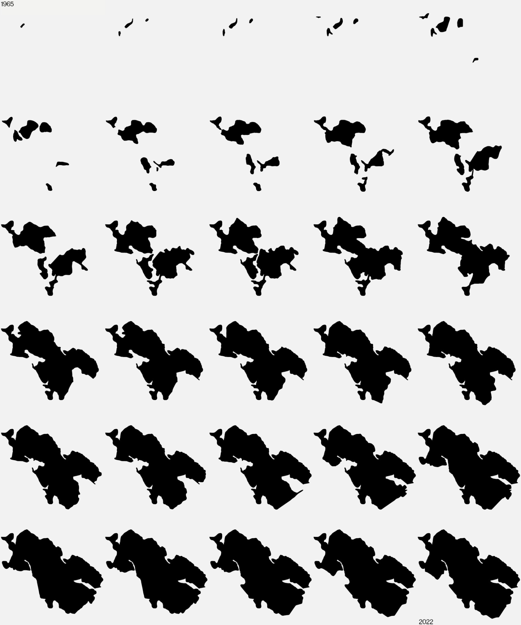
The infrastructuralisation has created a direct relationship between the volume of material excavated, the GDP and employment of the region, marginalizing other economic activities. Having no alternative that could balance out the jobs and income provided by the extraction, decreased production of lignite in recent years brings overall wealth loss to the region. The results of millions of years of geological processes have been exhausted. Being one of the largest coal mines in Europe, Ptolemaida became a hollow landscape. The mining operations extracted over 8.5 billion cubic meters of rocks and produced more than 1.7 billion tons of lignite. After 66 years, the landscape voids occupied over 17,000 ha and turned forests and agricultural areas into desert-like scenery.
The relatively short temporality of 66 years is directly interwoven with the Cenozoic period within the context of underlying grounds for becoming Western Macedonia an energetic hinterland. Similarly, the temporality of 150 years helps to better understand the sudden, radical change the region has undergone, shifting the populations, as well as the image of the landscape to strictly operational. 66 years produced a new type of territory, a new alteration of the hinterland, creating large social impacts, ecological costs, and sacrificing it. It strengthened links between cities and non-cities, as well as established new connections, since industrial acceleration does not limit only to city / non-city, but also non-city / non-city relations. Energetic hinterland also exists to supply other hinterlands, creating an array of dependences, boosting profits, and accumulating capital. Supporting various sectors, e.g., agriculture, fishery, maritime, and industry, it increases the production output, allowing to establish more eurozone and worldwide connections. Being a part of the international energy grid, it contributes to the profit maximisation of the sector.
60 minutes
"Extraction produces arrangements of matter that disfigure other organic and nonorganic arrangements, such as bodies and land.”[17] Lignite extraction relies on the logic of reallocation. It involves the processes of excavation, transport, and distribution. During its operation, it reshuffles various layers of soil from vertical order to horizontal arrangement of the overburden. Sediment that can be used as fuel is approximately 27% of what is being excavated. To provide enough fuel for the combustion, the Ptolemaida mine operates on 3 shifts, 24 hours a day, 7 days a week, for 66 years.
“The machine itself makes no demands and holds out no promises:
it is the human spirit that makes demands and keeps promises.
In order to reconquer the machine and subdue it to human purposes,
one must first understand it and assimilate it.”[18]
The pace of work is ordered by the pace of the main tool of the extraction, the bucket-wheel excavator. It is a heavy equipment machine, used in open-pit mining operations, which with consistent circular turns, removes approximately 12,500m3 of overburden per hour. The mine of Ptolemaida is equipped with 42 bucket-wheel excavators.[19] Circular cuts, both horizontal and vertical, spiral pits, and numerous shapes of dunes, stretching for over 170 square kilometres, are a result of slow, continuous, simple movements.

“If mining unearths the exoskeleton of geologic life to produce the nowness (or the now, now, temporality) of contemporary life (its energy and communication networks, its highways and pathways), it also creates an opening and the passageways of unintended fractures—fissures—that lead into other undergrounds.”[20] For every million tons of lignite produced, 185 jobs are maintained in the mining-energy sector and 725 jobs are created in the local labour market.[21] Currently, the Ptolemaida mine creates employment for around 3200 people, giving workers approximately 680 Euro per month.[22] Due to the extreme mono-functionality of the region, it is often the only choice for the people willing to live there. Successive generations are being involved in the extraction operations, which frequently take a toll on their health. Premature paternal deaths due to cancer, force workers to follow their fathers’ paths, as there is a lack of other job opportunities.[23] Each hour contributes to the cycle of dependencies and differences between city and non-city.
Small time-crystals accumulate, producing a hollow landscape. Economic dynamics, machinery, and people are involved in the relation of demand and supply. With each hour, the energy usage, essential to the urbanization processes, cuts out a consecutive piece of land, geophysically transforming it for millennia. Cities, located hundreds of kilometres from the Ptolemaida mine, have a direct influence on the economy, ecology, and sociology of the region, amongst other aspects. That influence is instant and has the speed of the electric current to be precise. One of the essential characteristics of energy logistics is the inability to store, leaving no margins for the supply and demand chain. The production of electricity is a direct response to the usage of a single moment. In that respect, flipping a switch in Athens or Thessaloniki can cause the turbine of the Agios Dimitrios Power Plant to start spinning. This is often used by the Public Power Corporation to exert pressure on workers and inhabitants of surrounding villages, threatening any operational disruptions that may cause power outages in the country. This illustrates the fragility of the region, being a “sacrifice zone”[24], entangled in the toxic process of supplying profit-oriented capitalism.
6 years
The energetic hinterland of Greece is facing the task of another dramatic transition. The decarbonization process to reach a net-zero emission economy by the mid-century requires a significant economic transformation. The Greek government plans to withdraw all lignite plants by 2028, with the majority of units being withdrawn by 2023.[25] It is 25 years earlier than the lignite industry anticipated based on the natural reserves of the Ptolemaida basin. Long-term dependence on extraction, lack of diversification, as well as the stagnation of other branches create a threat of losing thousands of jobs in the coming years. Due to political acts, the low-value, degraded landscape will suffer another socioeconomic impact, which will surely expose local communities. It is estimated that the delignification will result in a decline of GDP by 26%, loss of 21,00 jobs, and an employment reduction of 24%. The total income loss for the years 2013-2028 will reach €9 billion.[26]
(Image 7- Employment and GDP (€ million) in W. Macedonia)

The transition plans’ strategic direction requires the backing of transforming and differentiating the economic sectors. West Macedonia will partially remain an energetic landscape, replacing lignite with solar farms and hydrogen production facilities. Additionally, the area will be supported by a more diverse industry involving battery production, the return of agricultural production, and the development of sustainable tourism.
Even though often rendered obsolete, infrastructure systems are still needed. However, the case of Western Macedonia proves that capitalistic approaches of separation of industries to maximize profit are dangerous for the future existence of the hinterlands. Profit-oriented, monofunctional systems prove to create destructive relations between cities and non-cities. Instead, a new system is required, operating in synergy with different economies and ecologies. Referring to existing knowledge, hinterlands require a new model, with a variety of different, smaller activities. The landscape “needs to be reformed as a system of essential resources, services, and agents that generate and support urban economies.”[27]
“66 million years”
Hinterlands are places constantly undergoing changes – geological, ecological, economic, and sociological. Their characteristics are based on the dependence of their relationships with urbanization processes. On the continuum of their existence, their applications undergo numerous mutations, but the city / non-city relationship seems to persist. The current becoming of the hinterlands has reached a point of saturation. Any changes in their role render them vulnerable. Simultaneously, by relying their existence on extraction, they are progressing the exhaustion. In this way, this relationship makes the image of the hinterlands a place of capitalist machinery, where people and landscape become infrastructure in the process of capital accumulation. The delignification process, as well as the challenges and predictions facing it, show how unstable the position of the hinterlands is. Infrastructural configurations, which are now becoming obsolete, are not able to amortize the environmental costs. Non-city is a vulnerable place, degraded and eroded by the logic of profit maximization.
In the circulating history of events, the urbanization processes have reached a critical point. “66 million years” is an attempt to stimulate further reflection and investigation on the dynamics of the hinterland transition. The repetition of the first temporality points out the necessity of introducing the rejuvenation phase. Similarly to the process of lignitogenesis, ecological and economic layers need to accumulate to transform hinterlands sociologically and culturally. Operational landscapes must change their logic in a sustainable and democratic way. The next pace of the transition is an ambition to reverse and balance out the city/non-city relationships. The infrastructural landscape must be retrieved from the profit-oriented logic. The existing co-dependency of the economy and the environment needs to shrink and transform from mono-functional complexes to multidimensional, ecological systems. Perhaps exiting operational territories, and the socio-economic and ethico-aesthetic conditions they create can bring a different understanding of infrastructure. Further spatial research and design project aim to explore the opportunities of incorporating obsolete systems and machines accompanying them, to restore value to the degraded landscape. The operational logic of mining processes has created an effective tool for the transition of the landscape. Paraphrasing Lewis Mumford, we have to reconquer it and subdue it to human and ecological purposes.

[1] Grosz E. (2004) The Nick of Time: politics, evolution and the untimely.
[2] Ibid.
[3] Grosz E. (2005) Time Travels: Feminism, Nature, Power
[4] Overdijk M. (2018) Monuments and Mental Maps. Narrating the City and Its Periphery.
[5] Ibid.
[6] Ibid.
[7] Barikin A. (2019) Robert Smithson’s Crystal Lattices: Mapping the Shapes of Time
[8] Plagne F. (2018) Robert Smithson: Time Crystals
[9] Smithson R. (1996) Illustrations of catastrophe and remote times, after Barikin
[10] Metaxas A. (2007) Geological Evolution - Stratigraphy of Florina, Ptolemaida, Kozani And Saradaporo Graben
[11] Graben - an elongated block of the earth's crust lying between two faults and displaced downwards relative to the blocks on either side, as in a rift valley. (Oxford dictionary)
[12] Metaxas A. (2007) Geological Evolution - Stratigraphy of Florina, Ptolemaida, Kozani And Saradaporo Graben
[13] ibid.
[14] ibid.
[15] Fotiadis M., et al. (2019) MEGALO NISI GALANIS (6300–1800 bc ): Constructing a Cultural Sequence for the Neolithic of West Macedonia, Greece
[16] Kaloudis G. (2014) Ethnic Cleansing in Asia Minor and the Treaty of Lausanne
[17] Yusof K. (2021) Mine as Paradigm
[18] Mumford L. (1934) Technics and Civilization
[19] Pavloudakis F., et al. (2020) Sustainable Rehabilitation of Surface Coal Mining Areas: The Case of Greek Lignite Mines
[20] Yusof K. (2021) Mine as Paradigm
[21] Pavloudakis F., et al. (2020) Sustainable Rehabilitation of Surface Coal Mining Areas: The Case of Greek Lignite Mines
[22] Costa L. (2020) Ptolemaida – life in the shadows of a coal mine
[23] Pantelia A. (2018) Lignite mining: Greece’s dirty secret – in pictures
[24] Brenner N., Katsikis N. (2020) Operational Landscapes: Hinterlands of the Capitalocene
[25] Hellenic Republic (2019) National Energy and Climate Plan
[26] Pavloudakis F., et al. (2020) Sustainable Rehabilitation of Surface Coal Mining Areas: The Case of Greek Lignite Mines